 Return to the Home Page | Translate this Page
 The Engine of Destruction
within this Earth
The Engine of Destruction
within this Earth
The Catastrophic Destruction and Restoration of Pangea
Catastrophes at the Time of the End – Part Eight
Translation by the New King James Version
Robert D. Mock MD
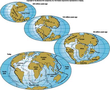 According
to geologists, at one time, the world landmasses were congregated together in
an area called Pangea. Instead of seven major continents lying somewhat
equidistant around this globe in balanced continental shelves, there was one
giant landmass.
According
to geologists, at one time, the world landmasses were congregated together in
an area called Pangea. Instead of seven major continents lying somewhat
equidistant around this globe in balanced continental shelves, there was one
giant landmass.
Continental Plate Movement – Canadian Society of Petroleum Geologists
This may seem a foreign thought to most individuals, but to BibleSearchers, it conceptually is compatible with the picture of this world when God created it with the Garden of Eden.
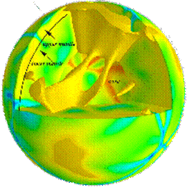
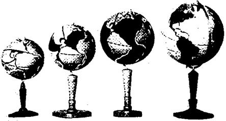
Global tectonics is the study of the origin and distribution of the continental landmasses on this globe. Today it is recognized as a disciplined science which views this world as a dynamic and interactive orb, interacting with every living creation on the face of this globe and interacting with the other planets and sun in this solar system and also interacting with the cosmos. Here is a picture of how one geologist imagines the placement of the continents.
 What has disturbed Christians is not
the conceptual reality of geological science, but how to incorporate their
concepts of geological time of millions of years into our understanding of the
historical time of Homo sapiens, human life as we know it.
What has disturbed Christians is not
the conceptual reality of geological science, but how to incorporate their
concepts of geological time of millions of years into our understanding of the
historical time of Homo sapiens, human life as we know it.
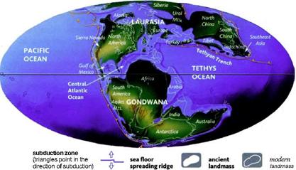
A Model of Laurasia and Gondwanaland in Ancient Pangea
Geologists place the
creation of this planet at about 4.5 billion years ago, in the Achaean era. To
even get a geologist and a fundamental Christian to sit down and discuss the
incompatibility of 4.5 billion years with the Genesis creation story set with
the genealogical record of the Torah to about 6000 historical years seems a
bridge to vast to conquer. To even discuss the theoretical concepts and
applications of geological change in reference to the Biblical picture involves
both parties in a morass of 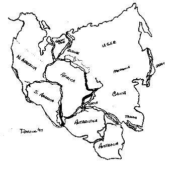 details rather than philosophical
concepts. In other words, get my details correct first, and then we will
discuss where you are probably wrong.
details rather than philosophical
concepts. In other words, get my details correct first, and then we will
discuss where you are probably wrong.
What I have discovered is that the world of the ancients is a world where a creative mind can entertain speculative concepts and still be within the same field of probability as the best of the evolutionary geologists and scientists.
In 1997, I decided to create my own Pangea, but with one exception. In many geological renditions of Pangea, the northern coast of Africa does not juxtapose to any land mass. This is strange as this is the land of Israel; this is the land of the Mesopotamian valley where most archeologists claim is where civilization began, in the land of Sumer.
Pangea with Jerusalem as the Center of the World – Drawing by Robert Mock 1997
Capturing the age old traditions of the Jews that the Temple Site in the site of the creation of the earth and the sacredness that the Lord of hosts places upon the city of Jerusalem in both the Old Testament prophets and John the Revelator, I used this as my starting point for Pangea.
Though the geologists discuss the separation of the continents in terms of millions of years, we know that this data is extrapolated by looking how fast the earth’s continents are separating today and projecting on how much time would it take to created say the Atlantic Ocean. We have learned enough to understand that the Lord of hosts has His own ways of doing things. We will discuss later how the Almighty God can lift up the Himalayas by a close flyby of another iron laden planet, and the giant mountain can be raised from its foundation in about 45 minutes in what is called the ‘grappling hook crustal deformation’. Let us open our minds and not consider our limitations but focus on the possibility of changing an ‘immovable constant’, a sacred cow, a hub upon which our theoretical concepts are built and see if natural science can become more compatible with the image given to us by God on how this earth was created and made to function.
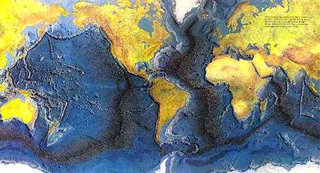
There is an awesome realization in the Bible and in geology of the degree in which our ‘stable earth’ has been moved and shaken from its original foundations. What is known is that the world is splitting and expanding, suggesting that at one time, in the pre-diluviun era, before the Noachian flood, the world was a lot smaller. The split and expansion of the world is occurring down the mid Atlantic ridge about equi-distant between the eastern coast of North and South American and the western coast of Europe and Africa.
Tectonic Plate Movements and the Expanding Earth
This separation of the continents has been theorized, using the vast computer laboratory of Los Alamos by John Baumgartner, to have included meters per day separation in the recent past compared to just centimeters per year now. The first clue is that there are no major mountain uplifts on either side of the Atlantic. In other words, there are no major continental plates jamming up against each other, causing mountain uplifts. This part of the planet looks as though it has been stretched, like an expanding earth.
 It was the creative
ideas of Hilgenberg, who proposed in 1933 the concept of an expanding earth.
In other words, as the continents were separated, there was also an associate
increase in the diameter of the earth also. On his globe, yes, the earth at
the time of creation was a smaller earth, than the earth we see today.
It was the creative
ideas of Hilgenberg, who proposed in 1933 the concept of an expanding earth.
In other words, as the continents were separated, there was also an associate
increase in the diameter of the earth also. On his globe, yes, the earth at
the time of creation was a smaller earth, than the earth we see today.
Hilgenberg’s (1933) expanding Earth “terrella” attributed to being the first small Earth models constructed. Small globe is approximately 60% of present Earth radius (From Vogel, 1983 reported in James Maxlow, Global Expansion Tectonics.
As we began to get more data from the expansion of the mid-Atlantic ridge, as the most classic case of separation of continents, we now can see the dynamic expansion in the continuous earthquakes and volcanism in this area. Over 170 shifts in the magnetic polarity on the floor bottom have been recorded suggesting that the earth made a magnetic polar shift over 170 times during the course of forming the present Atlantic Ocean.
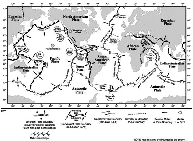
Yet on the other side of the world in
the Pacific Ocean, the geological evidence suggests the following. The major
Pacific land plate, in which the Juan de Fuca is one portion, and the Nazca 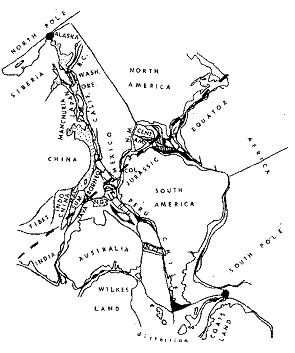 and
Australian land plate, collapsed and sank. Were these once inhabited lands?
Well, the South Pacific and Asian myths of the lost continent of Mu and
Lemuria, suggest that may have been the case.
and
Australian land plate, collapsed and sank. Were these once inhabited lands?
Well, the South Pacific and Asian myths of the lost continent of Mu and
Lemuria, suggest that may have been the case.
The Merging of the Continents as One Tectonic Landmass
What we suspect, is that the Pacific Ocean plates are taking all the pressure of the expanding Mid Atlantic Ridge. As such, the Pacific Ocean is actually getting smaller. Well, not too fast, but yet still in fact. Sunken land plates, being heavier, when colliding with floating continental plates, will subduct or move under the lighter continental plates. This we see all along the Pacific coast of North and South America. If you will also notice, that whole are is one of massive land uplifts or mountain chains. The Juan de Fuca and Pacific plates colliding with the North American plate and the Nazca Plate colliding with the South American plate have caused mountain uplifts along the entire edge of these continental plates.
Yet scientist are now
suggesting that the Pacific Plate may not even be in existence
as suggested and that the eastern Chinese coast in the era of Pangea actually
was connected with the Pacific coast of 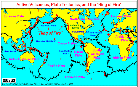 the United States.
Even the recent geological evidence of plate tectonics is being refined by the
newer evidence coming from the inner core of the earth, which is perceived as
being solid and the outer mantle, which is more molten and fluid.
the United States.
Even the recent geological evidence of plate tectonics is being refined by the
newer evidence coming from the inner core of the earth, which is perceived as
being solid and the outer mantle, which is more molten and fluid.
The Ring of Fire as Volcanoes and Earthquake are Activated along the Tectonic Plates
With this in mind, we can now visualize, with the expansion of the Mid-Atlantic Ridge, the eastern coast of Asia and the western coast of North and South American is putting a big squeeze on the Pacific, Philippine, Juan de Fuca, Cocos and Nazca plates. This has produced what has been the called the famous “Ring of Fire”. If you will notice, the majority of volcanoes are sitting along this area of tremendous clashing of the major continental plates. The main sliding areas are the Indonesian, Indian-Himalayan, and Peri-Mediterranean area. These occur along an east-west axis
The main pressure points are the KTT area along the Australian and Pacific Plates, the Caribbean Plate pointing towards the Mid-Atlantic Ridge. These occur along a north-south axis. As such, the most active region the world in terms of earthquake activity is an area northeast of New Zealand called the KTT or the Kermadec Tonga Trench. It is this area I feel that BibleSearchers interested in the natural cataclysmic signs at the end of times must keep a close look. This area appears to be an early warning area of seismo-tectonic activity for the whole world. When massive earthquake and volcanism is observed in this area, especially in the deep plates, then a major chain reaction may ensue.
On the other hand, most modeling done by more recent geologists in expansion plate tectonics, eliminate the Pacific continental plate, the Nazca, the Philippine plate. It also fails to explain the areas of subduction such as the Pacific Plate pushing underneath the North American Plate along the Pacific coast. (Scientific theories on expansion of the earth include: Halm (1935), Keindl (1940), Egyed (1956, 1960, 1961), Carey (1958, 1975), Heezen (1959), Brosske (1962) Barnett (1962, 1969), Creer (1965), Vogel (1983, 1984, 1990), Dearnley (1965a, 1965b), Shields (1976, 1979, 1983b, 1990), Schmidt and Embleton (1981), Neiman (1984, 1990), Perry (in Carey, 1986) as outlined in James Maxlow, Global Expansion Tectonics,

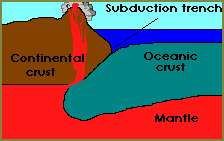
 The
interior of the earth is a fiery inferno of hot molten lava, called the mantle.
The continental crust or plates, after it was cracked by the Noachian Flood was
floating over this mantle. This is kind of like the chocolate coating over
chocolate coated cherries. When this molten magma erupts through the earth’s
crust, and starts pushing the continental plates apart, we have a picture of
the mid-oceanic ridge.
The
interior of the earth is a fiery inferno of hot molten lava, called the mantle.
The continental crust or plates, after it was cracked by the Noachian Flood was
floating over this mantle. This is kind of like the chocolate coating over
chocolate coated cherries. When this molten magma erupts through the earth’s
crust, and starts pushing the continental plates apart, we have a picture of
the mid-oceanic ridge.
 Geologists and sedimentologists such as Art Chadwich, with Earth
History Research Center, suggest that the continental
plates are predominately made by granite and metamorphic rock, containing
quartz and aluminum rich
rock, compacted or folded together under intense
heat and pressure, forming the floating continental plates. On the other hand,
main oceanic floors are predominately basalt, or silicon and magnesium rich
rock, which is dense and sinks into the earth’s mantle and forms the ocean
bottoms around the world. This basaltic stone is produced by continuous vulcanism
in the bottom of the ocean and covered with sedimentary stones, caused by
eroding sediments.
Geologists and sedimentologists such as Art Chadwich, with Earth
History Research Center, suggest that the continental
plates are predominately made by granite and metamorphic rock, containing
quartz and aluminum rich
rock, compacted or folded together under intense
heat and pressure, forming the floating continental plates. On the other hand,
main oceanic floors are predominately basalt, or silicon and magnesium rich
rock, which is dense and sinks into the earth’s mantle and forms the ocean
bottoms around the world. This basaltic stone is produced by continuous vulcanism
in the bottom of the ocean and covered with sedimentary stones, caused by
eroding sediments.
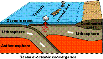
 The oceanic crust is much heavier than
the continental crust, so when these plates crash into each other, the
oceanic plate plunges downward toward the molten mantle, while the lighter,
continental plate rides up over the top. The forces driving the two plates
together are really intense, so the underlying oceanic plate (the 'subducted'
plate) creates a trench where it drags the edge of the continental
crust down as it descends underneath.
The oceanic crust is much heavier than
the continental crust, so when these plates crash into each other, the
oceanic plate plunges downward toward the molten mantle, while the lighter,
continental plate rides up over the top. The forces driving the two plates
together are really intense, so the underlying oceanic plate (the 'subducted'
plate) creates a trench where it drags the edge of the continental
crust down as it descends underneath.
The Floors of the Oceans and the Tectonic Plates
 We also
see this phenomenon in the oceans such as the KTT area along the Australian and Pacific
Plates and the Caribbean Plate pointing towards the Mid-Atlantic Ridge,
which produce severe pressure points and some of the largest recorded deep
penetrating earthquakes in the world.
We also
see this phenomenon in the oceans such as the KTT area along the Australian and Pacific
Plates and the Caribbean Plate pointing towards the Mid-Atlantic Ridge,
which produce severe pressure points and some of the largest recorded deep
penetrating earthquakes in the world.
The Marianas Trench is deeper than any mountain on the face of the
earth. At 10,924 m. or 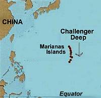 about 11
kilometers (5 miles) in depth, makes this one of the Natural Wonders of the
Natural World.
about 11
kilometers (5 miles) in depth, makes this one of the Natural Wonders of the
Natural World.
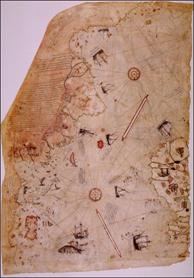 What
evidence in history to we have that there has been structural changes in the
topography of this earth? Charles Hapgood, professor of history and geology at
Keene State College and a correspondent with Albert Einstein did extensive
study of ancient
maps of the world. He came upon this old map, which showed a
surprising discovery.
What
evidence in history to we have that there has been structural changes in the
topography of this earth? Charles Hapgood, professor of history and geology at
Keene State College and a correspondent with Albert Einstein did extensive
study of ancient
maps of the world. He came upon this old map, which showed a
surprising discovery.
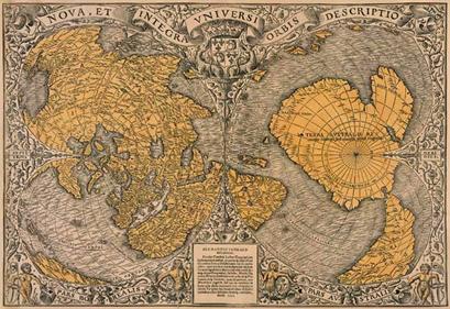 Once again the
problem to the modern historian with evidence of maps in the 1500’s of
Antarctica suggests that before this era, a sea faring people existed that
could circumnavigate the world, using cartography with such accuracy to show
details usually reserved for aerial photographic mapping.
Once again the
problem to the modern historian with evidence of maps in the 1500’s of
Antarctica suggests that before this era, a sea faring people existed that
could circumnavigate the world, using cartography with such accuracy to show
details usually reserved for aerial photographic mapping.
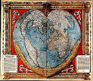
 Gerard
Mercator of Louvain, the famous mapmaker drew the world view after the 1531
heart shaped world map by Oronce Fine. This map was one of the first to
represent the New World with included the two land masses of North and South
American. Looking at the projections upon the map, suggests remarkabel
similarities of the Oronteus
Finaeus map of 1513
Gerard
Mercator of Louvain, the famous mapmaker drew the world view after the 1531
heart shaped world map by Oronce Fine. This map was one of the first to
represent the New World with included the two land masses of North and South
American. Looking at the projections upon the map, suggests remarkabel
similarities of the Oronteus
Finaeus map of 1513
Outside of the projections of an ice-free Antarctica is also the projection of Antarctica as being connected with the tip of South America.
Charles Hapgood made the controversial thesis of the map evidence of crustal shifting in which rapid shift in the continental plates on this earth of 15 to 20 degrees at a time. This could account, according to him, for the quick freeze of mammoths with tender spring vegetables grown only in temperate climates still undigested in their stomachs, finding coral beds under the Arctic Ocean and creating ice ages within days in which shifted ice zones immediately to temperate areas.
 So
here again, we have evidence of a continent in motion. The pictures suggest
that the Antarctica was at one time in the near history of man adjacent and
possibly within visible site of the southern tip of South America. This
evidence could be as late as the 3rd century B.C.
So
here again, we have evidence of a continent in motion. The pictures suggest
that the Antarctica was at one time in the near history of man adjacent and
possibly within visible site of the southern tip of South America. This
evidence could be as late as the 3rd century B.C.
Oronce Fine Heart Shaped Map– 1531
Also it suggests that the Antarctica continent was at latitude far enough away from the South Pole that it was not glaciated as we see evidence today. Yes, the thousands of feet of glaciers on the Antarctica might also be a recent phenomenon and not tens of thousands of years old. This may have been evidence of the final homeostatic balance or resting state of the major continents, not millions of years ago, but less than 2500 hundred years.
Understanding the dynamic relationship of this globe, the uniformitarian geologists were suddenly alarmed in the spring of 2002, when a reported 400 year old ice shelf in the Antarctica, called the Larsen Ice Shelf started collapsing in January 3, 2002 and by March 3, 500 billion tons of ice, the size of Rhone Island or Cornwall, England had broken off floating away into the Antarctica Ocean. Will the Antarctica once again in recent years become ice-free and what evidence of geology and archeology might we find there?
The Molten Plumes in the Mantle of the Earth.
 Giant Heat
Conveyor Belts in the Core of the Earth
Giant Heat
Conveyor Belts in the Core of the Earth
In 1998 is was reported in Discovery that a Dr Dietmar Müller from the University of Sydney, Australia along with Drs Walter Roest from the Geological Survey of Canada, and Dr Jean-Yves Royer from UBO-IUEM Domaines Oceaniques, France did a comparative analysis of the recent mapping of the ocean floors with the evidence we have of continental plate tectonics. What they found was evidence of plumes of magma within the outer mantle of the earth, which appear to be non-moving or stable. These molten plumes erupting from deep within the Earth’s mantle over a thousand miles and transport this primitive earth or molten rock not only up and down from the earth’s core to the mantle, but like a conveyor belt will push this molten rock sideways beneath the crust of the earth. The plumes begin as what is known as a volcanic ‘hot spot’, such as under Hawaii or Iceland and then travels to the middle of the ocean floor, such as the mid-Atlantic ridge erupting lava spewing out fracture zones of colliding continental plates. The lava flows out, cools and a new ocean floors are born.
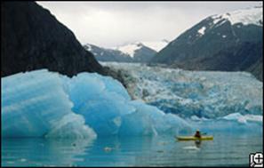 But it is not just earthquakes and
volcanoes that occur because of the plumes of molten rock moving up and down
the mantle and under the continental crust. In the Artic regions, scientists
have been observing the progressive shrinking of the vast glaciers and ice
fields in Alaska. The rates of glacier loss has doubled in the last 40 years
and about 10% of the rise in the world’s ocean levels is attributed in the loss
of fresh water glacier ice from Alaska alone.
But it is not just earthquakes and
volcanoes that occur because of the plumes of molten rock moving up and down
the mantle and under the continental crust. In the Artic regions, scientists
have been observing the progressive shrinking of the vast glaciers and ice
fields in Alaska. The rates of glacier loss has doubled in the last 40 years
and about 10% of the rise in the world’s ocean levels is attributed in the loss
of fresh water glacier ice from Alaska alone.
Glaciers in Alaska - Discovery
But it is not Alaska alone. The
glacier and snow laden peaks of the tropical mountains of Kilimanjaro in Africa
and the Andean ice rivers are threatened to disappear in the next 20 years.
Each year the Artic ocean ice cap is shrinking the equivalent to the size of
the Netherlands. Submarine polar ice cap measurements have recorded that the
average ice cap depth has thinned from and average of nine feet down to six
feet in thickness over the last 30 years. If you want to discuss global
warming, consider the fact that is may not be the result of man’s 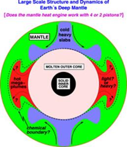 indiscretions such as global auto emissions,
but rather, it may truly be an Act of God.
indiscretions such as global auto emissions,
but rather, it may truly be an Act of God.
In the last decade, the top ten warmest years on record have been recorded. Six of those years have been in the past ten years. So we now have evidence that beneath the Antarctica and the Arctic these convection lava plumes are heating the crusts of the earth beneath these polar regions. In the past, these molten plumes were thought to sink into the depths of the earth at the poles and rise at the equator.
The Engine at the Center of the Earth - News in Science
 Yet all it would take to create a pole shift, all it
would take would be to shift the direction of the lava plumes and redistribute
the weight of the Earth’s mantle off center to its pole of rotation. When the
weight of these lava plumes become so concentrated in the polar regions, the
centrifugal force of rotation will force this heavier mass towards the equator
carrying the entire mantle and crust with it.
Yet all it would take to create a pole shift, all it
would take would be to shift the direction of the lava plumes and redistribute
the weight of the Earth’s mantle off center to its pole of rotation. When the
weight of these lava plumes become so concentrated in the polar regions, the
centrifugal force of rotation will force this heavier mass towards the equator
carrying the entire mantle and crust with it.
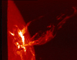
Solar Flare from the Surface of the Sun
With all the scientific skepticism of an Earth’s crustal shift, we now have a scientific model suggesting that the crust and the mantle of the earth can slid en mass around the core of the earth which will remain stationary. The geophysical poles would move to a different position, while the magnetic pole governed by the core of the earth would remain the same.
But what could be causing the increased excitement of the magma currents rising upwards causing eruptions of volcanoes in the temperate regions of the world? What we do suspect is that the ongoing solar storms actually increase the electrical activities inside the Earth, thereby heating the interior of the planet. The increasing heat in the iron core will activate further magma plumes and build increasing pressure along the entire ‘Ring of Fire’. What is this critical temperature threshold in which will cause the crust of the Earth, and the land beneath us to erupt or to shift or glide to another latitude? We don’t know, but what is known now is that it can happen.
Ezekiel 38: 16-20 - And thou will come up against My people Israel like a cloud, to cover the land. It will be in the latter days that I will bring you against My land, so that the nations may know Me, when I am hallowed in you, O Gog, before their eyes. Thus says the Lord GOD; Art you he of whom I have spoken in former days by My servants the prophets of Israel, who prophesied for years in those days that I would bring you against them?
‘And it shall come to pass at the same time when Gog comes against the land of Israel,’ says the Lord GOD, that My fury will show up in My face. For in My jealousy and in the fire of My wrath have I spoken: Surely in that day there shall be a great earthquake in the land of Israel, so that the fish of the sea, and the birds of the heavens, and the beasts of the field, all creeping things that creep upon the earth, and all the men that are upon the face of the earth, shall shake at My presence. The mountains shall be thrown down, and the steep places shall fall, and every wall shall fall to the ground.”
Part One - Planetary Changes at the Time of the End
Part Two – Isaiah the Catastrophic Prophet
Part Three - Major Earthquakes and Catastrophes in the Old Testament - Part One
Part Four - Major Earthquakes and Catastrophes in the Old Testament - Part Two
Part Five – Major Earthquakes and Catastrophes in the New Testament
Part Seven – Evidence of Catastrophes in the Natural World – Part Two
Part Eight – The Catastrophic Destruction and Restoration of Pangea
Part Nine - Eden as Pangea and the Flood as a Mass Extinction
Message from BibleSearchers
BibleSearchers scans the world for information that has relevance on the time of the end. It is our prayer that this will allow the believers in the Almighty One of Israel to “watch and be ready”. Our readiness has nothing to do trying to halt the progression of evil on our planet earth. In our readiness, we seek to be prepared for the coming of the Messiah of Israel so that goodness and evil will be manifested in its fullest. Our preparation is a pathway of spiritual readiness for a world of peace. Our defender is the Lord of hosts. The time of the end suggests that the Eternal One of Israel’s intent is to close out this chapter of earth’s history so that the perpetrators of evil, those that seek power, greed and control, will be eliminated from this planet earth. The wars of the heavens are being played out on this planet earth and humans will live through it to testify of the might, power, justice and the love of the God of Israel. In a world of corruption and disinformation, we cannot always know what the historical truth is and who is promoting evil or mis-information. We cannot guarantee our sources but we will always seek to portray trends that can be validated in the Torah and the testimony of the prophets of the Old and the New Testament.
FAIR USE NOTICE
This site contains copyrighted material the use of which has not always been
specifically authorized by the copyright owner. We are making such material
available in our efforts to advance understanding of environmental, political,
human rights, economic, democracy, scientific, and social justice issues, etc.
We believe this constitutes a 'fair use' of any such copyrighted material as
provided for in section 107 of the US Copyright Law. In accordance with Title
17 U.S.C. Section 107, the material on this site is distributed without profit
to those who have expressed a prior interest in receiving the included
information for research and educational purposes. For more information go to: http://www.law.cornell.edu/uscode/17/107.shtml